Barsetshire Pilgrimage (You’ll need a map!)
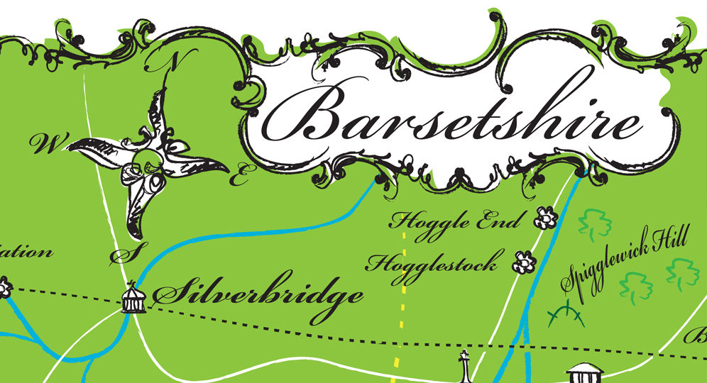
In Trollopiana Number 111, in the autumn of 2018, we introduced the creation of a new Map of Barsetshire, explaining the challenges that this had presented and trying to establish the need for such a piece of work, considering that several maps had already been created since Trollope’s death. Trollope’s own rough sketch, referred to in his autobiography and completed during the writing of Framley Parsonage, remained lost until it was discovered among family papers in the early part of the twentieth century.
The various subsequent attempts to recreate this well-loved fictional County were often compromised by:
- not having access to this basic source document,
- relying solely on the references to be found within the Chronicles of Barset and ignoring references to the County contained within other works by the author,
- coping with the apparently contradictory references made by Trollope himself where he may seem to have created a geographical anomaly and, finally,
- the temptation of nearly every aspiring cartographer to include imaginative elements of their own that cannot often be justified. I admit that I have often been tempted to do this myself but sincerely hope that I have been held sufficiently in check. I have already described the decision-making process in my previous article.
To produce the basic map, it was necessary to create a large database of references to Barsetshire taken from any of the author’s works where these occur. Anomalies thus created then had to be made to conform. Certain specific mileages could not be ignored. Finally, a reasonably accurate sketch was created and forwarded to Simon Grennan for translation into an artistic whole which the Society then produced as a limited-edition souvenir tea-towel which was produced for sale in time for Christmas 2018. I am pleased to report that this item was totally sold out very quickly.
However, in order to make the tea towel as picturesque as possible, vignettes were included that covered wide acreage and place names were increased in size for clarity which meant that some elements of the core map had to be compromised and some geographical features and place names had to be omitted (although their location could be guessed). For this reason, we decided that, for the true Trollope afficionado, a more practical and useable version of the map should now be produced. This proved to be not quite the straightforward task that it might appear!
To begin with, the attractive vignettes were moved to the border of the map, new symbols were devised, and the text was reduced in size in order to enable us to replace landmarks and locations that had had to be taken out. Working with Simon Grennan is always a pleasure from the artistic point of view but, as we worked to achieve accuracy in one area, inevitably impossible consequences were created in others and everything had to be reconsidered, often going back to the database and the original mileage statements that could not be changed. As an example, there are natural clusters of locations, in particular around Framley Court and Barchester itself, where it proved challenging to show every location exactly and to mark it sufficiently. The routes of the railway lines were sacrosanct because of Trollope’s own sketch but we decided to include some waterways in the areas where we knew they existed but without naming them. It is, of course, very tempting to suppose that a stream identified as a flumen by some ancient Roman Centurion might, with the passage of time, and local dialect, have evolved into a River Plume which might, just possibly, have influenced the choice of place names such as Plumplington and Plumstead Episcopi. Sadly we can never be sure of this.
Trying to keep all the relationships and mileages between several places accurate in limited space, and according to an established scale, was always difficult and while I was attending to something else I had not noticed that Plumstead Episcopi had been slipping away to the south so that it had become fully five miles further from Barchester than it should have been. Moving it back to its correct position, of course, affected its relationship with Ullathorne, St Ewolds and Plumstead Coppices all of which had to be taken into account. Eight redrafts later the Map was ready to be produced in its new form!
The Society is delighted to have finally created what we hope will be the most accurate and definitive version of ‘The Beloved County’ to date and, of course, continue to be grateful to those few cartographers of the past who have worked so hard on the same problems. We hope that it will be enjoyed by all Trollope enthusiasts.
The finished product has now been lodged at all the Copyright Libraries (including Trinity College, Dublin) and the original concept had been that it would be relaunched at this year’s AGM and then sold at Society Events and local Discussion Groups. Unfortunately, the effect of the recent pandemic has made this challenging for the time being. We have, therefore, decided that, from 1st September 2020, the map will be available for delivery by post. As the edition is a limited one, early application is advised.
Copies in A3 size may be ordered from the Trollope Society shop. The cost of each map is £15 and we will be offering free postage within the United Kingdom. For overseas orders the usual additional postal charges will be applied.
by Michael G Williamson
Purchase copies of the new Barsetshire map from the Trollope Society shop